Part 1 of 2 - The Theory
As the various professions collaborate on projects, the one thing that always seem to get a bit loose – even completely unhinged – is the project coordinate system(s). Certainly, there is a lot of misunderstood detail around this very fundamental aspect of data coordination leading to lost productivity through a lot of wasted time.
As a survey firm, we tend to be in the middle of it. So here is a bit of a background piece on some theory, why coordinates matter, what choices you have in terms of coordinates to use .. perhaps a even a mild rant.
Part 1 is some necessary theory .. I know I know .. as your eyes glaze over and you want to jump a few sections, hear me out. Part 2 will be more of practical look at how you might set up the project from a surveyor's perspective.
What is a coordinate system?
Seems an obvious question doesn't it?! But have you ever considered what you are doing the second you import survey data into Revit, centre-to-centre, acquire shared coordinates and start moving and rotating with abandon? You are manipulating coordinates – and your choices here can be important. More correctly you are defining transformations and rotations between coordinate systems – and Revit "handles" three of them!
Wiki defines a coordinate system as:
"In geometry, a coordinate system is a system that uses one or more numbers,
or coordinates, to uniquely determine the position of the points
or other geometric elements on a manifold such as Euclidean space."
That is a pretty academic description – that gets us as far as having three numbers – X,Y,Z – to define a point in "space" .. but for all of this to work we need to add a few more terms.
Geodetic Datum (again Wiki):
"A geodetic datum or geodetic system is a coordinate system,
and a set of reference points, used to locate places on the Earth."
Now things are getting interesting. The above mentions "locate". I prefer to think of that differently in terms of a description that is agreed upon to communicate the same locations on Earth. So using a value – X,Y,Z and agreed horizonal and vertical datums, two or more people are describing the exact same place on Earth. This "description" could have been the result of a measurement or could be something that needs to be measured and marked on the ground – either way communication was successful.
There is another new term there:
"A datum is a reference system or an approximation of the Earth's surface
against which positional measurements are made
for computing locations." [Wiki]
To boil this down – a datum is something everyone agrees to call "0" (in X,Y and Z) and measure from there.
Height Datum
Let's start the discussion with height (the "Z") – probably the easiest. We use height datums every day. Australian Height Datum (AHD) is something you have probably come across – but there are others.
What about your Revit level "Ground"? Is that not a datum? You will note I scrubbed through the bit in the definition "on the Earth's surface" from Wiki. You design against a level .. ground .. the floor .. that is your datum – then you go up 2.4m (say) for the ceiling and so on. If you had a point on the site on the ground floor marked and called it "0", everything could still work!
But to avoid confusion however, mostly everyone uses AHD (and yes for the purists out there, there are other state based datums etc – but trying to keep it relatively simple). The "Australia" bit gives it away – but other countries naturally have their own.
Australian Height Datum (AHD)
AHD is derived from the mean level of 30 tide stations around the country during 1966 to 1968. The relative heights between the tide stations were measured (and adjusted) using two-way levelling – yep – the old level and staff – all up, some 97,230 km of double level runs across the whole country. No one can say surveyors aren't a persistent bunch at least!
And note "mean level" too – did you know the eastern coast has higher ocean levels? Ocean temperature and salinity affects ocean height – our east coast Pacific Ocean is warmer – and therefore higher than the west coast Indian Ocean – by over a metre.
Now we have our "0" or 0.000m AHD. Reference marks placed and similarly measured with double-run level-and-staff from national reference marks, are nominated as Permanent Survey Marks – bench marks – from which all subsequent measuring can be reliably done – there is a vast network of these to varying degrees of accuracy.
If you are in Brisbane – you can find " PSM 1" on the window sill to the old Lands Building – in Stephens Lane, just off William Street – but these marks are everywhere, and we can easily consult a database to find their locations and AHD values.
When we survey a site, we bring this AHD value in (technology choices aside) to establish local site bench marks for convenience – saves us going back to the distant permanent survey marks. We subsequently rely on these marks to measure features or for setting out heights – height of slabs, kerb and channel and so on.
Your Surveyor – the link between virtual and physical
An important point to note here – the datum – is a physical thing! A mark, a screw in concrete, a nail in bitumen. We create these "witness marks" so we can re-occupy a point and measure something again – it is repeatable and verifiable - you have no doubt seen a tripod or two with a prism next to a building site - this is set up over a control point.
The permanent survey mark we used are references (it is good fieldcraft to "close" against more than one), the local site bench mark can similarly be referenced and there is legal traceability.
We keep field notes (legal obligation) and use calibrated instruments (again a legal obligation) – but the most important thing to take away from this is there is a link between the physical world – the screw; the nail – the reference mark and the virtual – the CAD drawing; the site sketch; the model.
Your surveyor, hopefully Bennett and Francis (shameless plug), maintains this physical-virtual link and we go to great lengths to make sure it is right – double-run levelling, adjusted traverses with loops and redundancies, accurate, reliable and calibrated instruments – all to make sure the X,Y,Z values of our "control" (or reference marks) are as accurate and precise as necessary.
So when the first thing you do is take our data into Revit and move it and spin it – it breaks this link and pisses us off – especially when we get data back from the virtual world (your model) like a fancy new building – and we now need to put in physical marks in the right place for a builder – we first have to work out what's gone on and re-establish this link.
Now we know why you do this .. it looks better on your sheet .. or Revit doesn't like big coordinates .. or you just didn't realise the ramifications. Most other software doesn't run three simultaneous coordinate systems – only one. So when an engineer gets data from us for Tekla or 12D say – they just use it as it .. and vice versa.
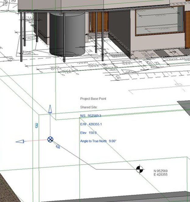
So when your surveyor asks for the Project Base Point it is the transformation and rotation we are chasing. When your surveyor asks you where you got your base data from and you digitised it from a PDF – there is no existing link to the physical world at all and our millimetre perfect control system is useless because we are about to fudge it from imprecise building corners .. it just kills us.
What about Horizonal Datums?
Time to jump down the rabbit hole.
Before the Global Positioning System was common place, getting real world coordinates was a pain in the arse and completely unnecessary. We could probably count on one hand the number of sites we used AMG (the precursor to the more familiar MGA) for – for 99.999% of our work, which is localised surveys – we would use an assumed coordinate system – so we would install a mark (screw in concrete say), call this mark 1000.000 E, 1000.000 N and go for it from there.
Generally, the survey's azimuth would be from previous cadastral work or if we were stuck (or more keen) from a "sun obs" – you will no doubt have found various versions of "North" around. I'll leave grid convergence to another day!
Somehow, we managed to build all manner of things and manage a cadastral titling system without GPS and real-world coordinates – totally amazing.
Remember – all we needed was an agreed way to communicate a link between physical-to-virtual (including paper maps) and virtual-to-virtual in the case of transferring CAD for the last few decades.
Back in the day, unless you were managing massive linear infrastructure (think road/rail/sewer/electrical etc) or massive campuses (eg an airport), or were maybe government, then a local coordinate system is more than appropriate.
So now we have GPS (USA system) – or more correctly GNSS (USA + Russian GLONASS + Chinese BeiDou + EU Galileo + Japan QZSS etc) – which makes getting real-world coordinates a breeze, what horizontal datum should we use?
Bloody good question ..
What are GDA, MGA and epochs?
We need to dive back into theory.
GDA94 – Geocentric Datum of Australia
"is defined by the coordinates realised on the Australian Fiducial Network (AFN) geodetic reference stations,
referred to as the Geodetic Reference System 1980 ellipsoid (GRS80),
determined within the International Terrestrial Reference Frame 1992,
at the 1 January 1994 epoch."
WOW. What? Basically – all this means is we draw an mathematically perfect spheroid around the Earth's imperfect surface – an ellipsoid as an average – and get the coordinates of a few high-precision GNSS antennas around the country in relation to the GRS80 coordinate system on 1 January 1994. Why is 1994 important? Oh boy – this is a goodie .. read on.
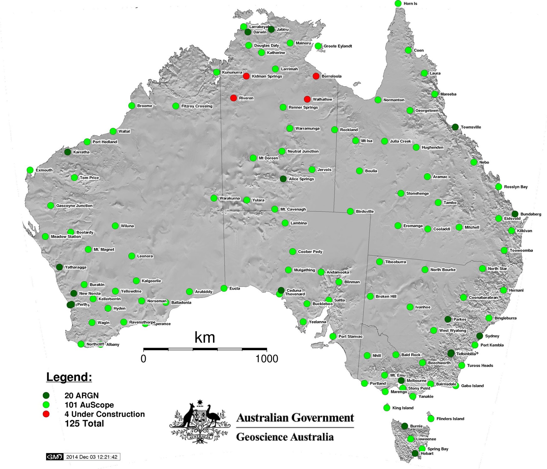
Image: CORS Reference stations operated by Geoscience Australia.
Epochs
The reference time is important because everything is MOVING. Australia moves roughly 7cm per annum north east – so our coordinates with respect to other international reference frames also move.
The GNSS system using the WGS84 coordinate system and there is a transformation between WGS84 and MGA94. In the years since 1994, Australia has moved roughly 1.8m.
To better align with GNSS – we now have GDA2020! A new observation date and transformation that describes the current location of these GDA reference stations within GNSS (WGS84) and the other international reference frames.
Wait! The MGA coordinates can move?? Sure can - well at least Australia slides within the international frames every day. When we go out with GNSS, we often are measuring our position in relation to other GNSS antennas with published coordinates nearby, there is that CORS thing again. CORS - or Continuously Operating Reference Station - is a GNSS unit that runs 24/7 and supplies its data for computations in either real-time (eg the survey network rover) or for post-processing (eg you get RINEX file and compare that to the RINEX you got with your own unit) - even drones these days do this sort of thing.
For real-time work, our survey-grade network rovers talk via mobile phone to a network of bases (CORS) and between them, they calculate the current position of our surveyor compared to the base station(s) and apply the "static" published coordinates ie MGA94 or MGA2020. The bases have moved since the coordinates were published in an international sense, but it all works out because the measuring we are doing today is RELATIVE to the published coordinates from 1994 or 2020. Get it?
MGA94 – Map Grid of Australia
"Is a metric rectangular grid coordinate system. It is a 2–dimensional Cartesian coordinate system
based on the Universal Transverse Mercator (UTM) projection system
and the GDA94 datum."
Critically here – MGA is a projection of the Earth's surface on to a flat plane, to get a nice grid as opposed to spherical lat and longs. Think of a flat slice through the curvature of the Earth (some Earth above the slice in the middle and some below at the edges). A diagram helps ..
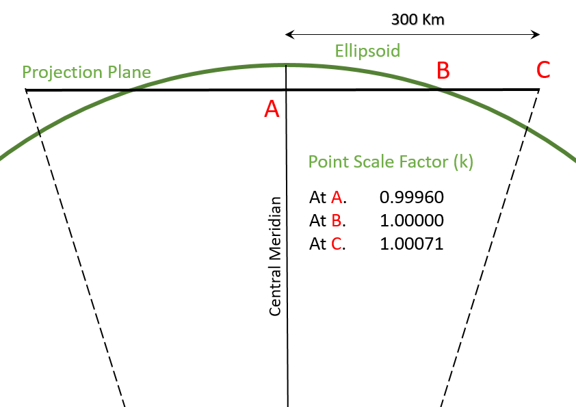
Above diagram: Extract from The Map Grid of Australia 1994, A Simplified Computational Manual, showing the Scale Factor will vary with the distance of the survey from the Central Meridian allowing for the East-West curvature of the Earth.
Now imagine your building in the middle of the slice (or Zone - eg MGA Zone 56) and draw some lines between the corners of your building from the centre of the Earth – to intersect the flat plane/slice below your building – the 2D coordinates of the intersected points on the flat plane – are the X,Y (in metres) of the coordinates of your building corners.
But do you see what projection just did here? Your building just shrunk. If you compare the length of the lines of the side of your building in the MGA-world compared to actually measuring it with a laser – you will see a difference. The difference isn't huge for small sites – you can basically disregard, but it starts to creep up. In Brisbane – this scale factor is roughly 0.9996 - you lose 0.4mm-per-metre. Not much hey? Now get yourself a 200m building – your building just shrunk 80mm in MGA compared to real life.
So some GOTCHYA's here – if you have data that is described as MGA – you need to know a few things:
- Which epoch is it 1994 or 2020 – there is nearly a 2m difference – this is going to become more important as we overlap old and new data;
- is it scaled or plane/ground distances? If ground distances – what was the scale point and scale factor used.
What do you mean MGA-scaled or MGA-plane?
Personally, MGA should be MGA – just pick an epoch, but I am a bit of purist. If the data isn't MGA, what the hell is it?
The "alternative" is to have a pseudo approach and have the data on MGA azimuth (ie grid north) and a scaling point in the survey (preferable in the middle) – accurately located on MGA94 or 2020 – and then have all the other data in normal, measured "ground distance" metres from there – so not scaled - call it pseudo-MGA.
Problem is – on a big site, the difference between MGA and this pseudo-MGA can add up very quickly – we had a gas line going in the other day 300mm out of position because the data was MGA94-plane and the GNSS tools the gas guys were using expected MGA94 to match the satellites. Same problem would exist for the graders or other machine guidance stuff. Essentially, survey-grade GNSS gear can spot the difference!
You can read a HEAP more about this geodetic stuff at ICSM
Part 2 will look at what we reckon we'd do for Revit set up.